This site has been optimized for PC and laptop use. Due to lack of physical keyboard and mouse pointer; or because of the smaller screens, may not be usable on tablets and smart phones. Hasn't been tested on iPads with keyboard and mouse pad. Uses Ruffle Flash emulator.
IF YOU RECEIVE AN ERROR MESSAGE FROM YOUR BROWSER, REFRESHING THE PAGE USUALLY RESOLVES IT.
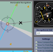
The RMI (Radio Magnetic Indicator) Simulator was designed to demonstrate the approximate indication that an RMI would display with varying positions of an aircraft in relation to certain navigational facilities.
Instructions:
Select desired Navaid type and settings. Drag aircraft on horizontal or vertical panels to change the aircraft's position in relation to the facility. If North Up is selected aircraft heading changes can be set by positioning the cursor close to the aircraft on the horizontal panel then clicking the button when a "-" or "+" appears. If Heading Up is selected, aircraft heading changes can be set by positioning the cursor close to the navigational facility on the horizontal panel then clicking the button when a "-" or "+" appears.
When Heading Up is selected, even though it may seem that the aircraft rotates around the navigational facility, the aircraft remains in the same position when changing heading. The reason for this is that the display will always show the navigational facility in the center of the display. This means that regardless if North Up or Heading Up is selected the aircrafts position will always be relative to the navigational facility.
General Explanation of Features:
Compass Rose - Used as an aid to show the orientation of the Horizontal Navigation panel. It serves the same purpose
as the compass rose symbol on IFR enroute charts to show direction in relation to the magnetic north.
Projection Flags - The projection flags serve to help visualize how and where the projection is made from the Horizontal
Panel view. Notice how the aircraft moves on the Horizontal panel when it is dragged on the Vertical panel and vice
versa. The movement is made in alignment with the projection flags. The projection is made according to the heading,
unlike
in the VOR and HSI simulators which are done according to the course.
Horizontal Panel - Displays the horizontal position of the aircraft in relation to the navigational facility the same
way an IFR enroute chart or an approach plate's plan view would.
Vertical Panel (Not applicable to the NDB navigational facility) - Displays the vertical position of the aircraft
in relation to the navigational facility the same way an approach plate's profile view would. It is used for several
purposes:
1. Higher altitudes increase the diameter of the cone of confusion (zone above and around the VOR facility where
the RMI receiver does not work properly and will typically point to 180 to show this error) .
2. The DME measures slant range distance from the aircraft to the facility. Being able to control the altitude allows
you to determine its influence and consequently the error associated to it.
Navigation Aid Type - Selects the type of navigational facility. Some features such as DME or glide slope will only work
with certain types of facilities.
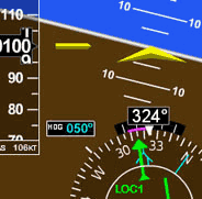
Needles - There are two needles in this RMI model. The yellow (VOR feature) needle is associated with a VOR,
VORATC, Localizer, LDA, or SDF facility. The green hollow needle (ADF feature) is associated with an NDB facility
and is part of the ADF function of the RMI. In practice these needles work independently and can work with two
facilities simultaneously. For simplification purposes the simulator uses one or the other and behaves as if one were
operating and tuned to a station and the other was not tuned to a station and vice versa depending on the
navigational facility selected. The two needles have two distinct behaviors when not receiving an adequate signal.
The yellow needle will always point to the 180 heading of the RMI when not receiving a signal. The green needle
will stay at 3 o'clock position regardless of the heading.
Settings Section - Select and activate different features.
Information Section - Displays information such as heading, and altitude. (This section cannot be changed by the user).
*Please note that DME may not be present together with localizer, back course localizer, LDA or SDA approaches. The DME distance shown is the approximate value a DME would indicate if such navigational facility were collocated.
CAUTION: The behavior of the RMI and other information displayed is approximate for illustration purposes only and may not reflect the actual readings on the RMI and DME.
Navigation Simulator
Check out our online version that runs directly on this website, and can be viewed on a Windows PC, Mac, or Linux OS. Practice in this simulator specifically designed for learning the basics of instrument navigation.
There is also the traditional Navigation Simulator that runs on PC Windows as a standalone app. Try the Navigation Simulatorfor for PC. Now completely free — forever!.
A Multitude of Other
Online Simulators
No installation required. These simulators are ready to run on your web browser and have a rich set of features. Practice basic VOR, ADF, RMI and HSI intrument orientation and execute holding patterns. Other simulators include pitot static system and altimeter errors. Click here to go to main online simulator page.
By Luiz Roberto Monteiro de Oliveira. Screenshots and video captures allowed (personal, business or military)
as long as credited to author and link to this site or URL included. Permission required for all other uses.